Sunday, June 29, 2014

Day 31 Price, Utah to Moab, UT and Arches National Park

Who turned on the heat ?


After the ride yesterday through heat and city traffic we were slow to rise this morning.  Walking outside to load the bike I was reminded that it's now hot outside even in the morning.  Just a few days ago I was wearing  an insulated lining in my jacket but now I'm sweating.

After a quick breakfast we head south to Moab.  Red rock country.  The landscape becomes a hodgepodge of canyons and rock formations.  It is hot, nearly 100 degrees by the time we reach Moab.

A month in cooler climates has me hugging the shade as Kathy shops for knick knack patti wacks in the many stores catering to tourists, i.e., us.  Some businesses have water misters to help cool potential shoppers.  I stand under them like a pig in slop.  Aaahhhh.

I want to go see the Arches National Park, but not in this heat.  We decide to spend the night here at Moab and get to the park earlier to avoid having a heat stroke.

The next morning we head to Arches National Park.  The traffic is not bad and we are able to see the arches pretty easily from the bike.  A lot of people were hiking ,walking right up to the monsters of sandstone.  My view from the bike was good enough for me, and Kathy.  Had we had proper hiking boots, and 20 degree cooler weather we might have been a bit more adventurous.

I still don't know why the park rangers wouldn't let us ride the bike up to the arches....

The park itself is a beautiful place. The folds of sandstone, towering monoliths, and of course the arches all painted various shades of red is definitely worth seeing.

After seeing the park we head for higher ground and cooler weather.
Price to Moab
Arches National Park


Friday, June 27, 2014

Day 30 Glenn's Ferry, ID to Price, UT

Get along little doggies


Leaving out of Glenn's Ferry we hit the freeway for a bit until we connect to some farm roads that will still get us where we're going.without the monotony of the interstate.  Small towns and ranches unfold on the vast plains.  The roads are as straight as an arrow and other traffic non-existent, I give the Grey Goose some reign and eat up some miles.  Until....

Until a small sign says road closed, DETOUR.  Evidently in the middle of nowhere this highway begs attention.  So we turn onto a graveled road and get behind the only other vehicle I've seen.  A large 18-wheeler kicking up such a cloud of dust we could barely see it.  I'm sure he couldn't see us either or he would pull over and let us around, wouldn't he...?

So we hang way back out of the dust, even stopping occasionally for Kat to take a picture.  Finally the 12 mile detour is over and on toward our next stop, 

Until we get stopped again.  This time not by local law enforcement, but by a cattle drive.  I had noticed little piles of manure in the road and figured since we weren't in moose country it might be cattle.  I'm smart that way.  I reduce speed expecting Longhorn cattle to somewhere ahead.  Topping a hill we come upon not Longhorns but Black Angus cattle being driven down the road to the next pasture.  We slow to a stop and talk to a rancher astride a beautiful cutting horse.  He is amazed we have been to Alaska.  He tells another horseman, which I take to be a grandson, to part the cows so we can pass through.  We tell him thanks and as he waves goodbye says, "Eat more beef".   The youngster on his own cutting horse clears a path and soon we are on our way again.  See what you miss by staying on freeways. 

We are heading toward Promontory Point at the Golden Spike Historic Site.  As we drive toward the park, the winding road we travel passes over the original railroad dump, or fill. Various signs offer trails where you can hike and see more....we decline.  Once to the visitors center we flash our National Park Pass and go in.  Lot's of info on the Golden Spike event is here, with videos and dioramas telling how it was all done.  I skip it.

We go directly outside to the train engines and the spot where the last spike was driven.  But it wasn't there. I mean I knew a golden spike wouldn't be there, but I thought a reasonable facsimile would be.  Nope.  Just a replica of a tie with a small plaque marking the spot.  The reasonable facsimile is inside. 

A little disappointed we explore the locomotive engines.  From a distance.  Please do not climb on engines.  I see why, they are very pretty engines, not what you would expect from such old engines....Hmmm.  It seems the original engines were scrapped after years of use. These fine replicas were built in 1979 by contractors who reproduced them using exact measurements taken from the original photographs.  So we take our original photographs and head further into Utah. Here's some interesting information, The two engines that played a big part in history were both an accident.

We hit Salt Lake City and the freeway during rush hour.  I should say we got back on the freeway at Brigham City and got off the freeway at Provo.  Over 100 miles of rush hour traffic...Whew !!

Finally we clear the interstate and make it to Price, Utah.  As warm as it is this evening, tomorrow promises to be a hot one


Wednesday, June 25, 2014

Day 29 Lewiston, ID to Glenn's Ferry, ID

Rivers, rivers, and more rivers


Leaving Lewiston, Idaho on highway 95 south didn't seem like that big of deal.  That quickly changed.  The farmlands variety of green and yellow hues changed with each rolling hill.  Old barns kept Kathy snapping pictures and the curvy roads kept my attention focused.

I found a turnoff that I had read about called the "Old Winchester Grade".   About 18 miles of narrow blacktop that gains elevation rapidly with many hairpin curves that have no shoulder but instead a straight drop-off to the grasslands below.  I hugged the center-line.

Where the grasslands, wheat fields, potato crops, and alfalfa ended  the mountains and rivers began.  First the Salmon River kept us company as we followed 95 south.  Rafters navigated the rapids while we tried to navigate the traffic.

While laying out this route over the past several months my main goal was to have beautiful scenery along with curvy motorcycle roads.  I however didn't count on Sunday traffic in God's beautiful country.  Traffic was heavy and mostly going in my direction.  I was trying to keep my speed down since yesterday's ticket, but when the speed limit is 65 and traffic is running around 55 I get a little impatient.  I started passing a few vehicles at a time when safe, slowly whittling away at the source of obstruction.  You know, that one vehicle that has the whole thing bottle necked.

Finally I see the problem, a white truck.  As I pass it, blue lights come on.  Evidently I have just passed a county sheriff.  Pulling over in the first safe area, I am just a little disgruntled.  But of course when the officer ask for my credentials I'm polite.  It seems he thinks I've been darting in and out of traffic and being unsafe.  I do not argue.  This is the most dangerous road in Idaho I learn.  I was unaware of that I tell him.  How fast was I going I ask, 76 he says.  Again I do not argue,  I do not think I was going that fast, plus the lights came on as soon as I was beside him.  I accept the verbal barrage and he lets me go.  Now that he is behind me traffic flows smoothly all the way to Boise.

Back to the scenery.  The Salmon River turns away from the highway and is replaced by the Little Salmon River and then the Payette River.  All beautiful and I see why this route was so highly recommended,  I do wish we had rode it mid-week though.

I steer west of Boise and cross the Snake River.  More crops and grasslands all irrigated by the Snake.  The fields that are not irrigated are brown. We are in an arid area that has to have the Snake River's water to produce.

Starting to feel the rigors of riding all day I stop at a place called Givens Hot Springs.  It promises cabins, tent sites, and relaxing springs.  After talking to the owner we go to check out a cabin. Having stayed in old cabins twice before on this trip, I thought it would be okay.  Wrong.  When we opened the door of the cabin it was an instant NO.  Old is not the word for these cabins,,,more like ran down.  Near falling down.  Not even a bathroom.

We climbed back on the bike and continued along the Snake River.  It's nearly dark we come upon Glenn's Ferry, a small town of just over a thousand people.  There we find the Redford Inn, another outdated motel but very clean.  The restaurants in town are already closed so we stop at a grocery store and buy a package of baloney and a loaf of bread.  Fine dining in Glenn's Ferry.  Stomachs full we turn off the lights, tomorrow we'll see where the east and west was joined together by steel rails !

Pics for Lewiston to Glenn's Ferry

Sunday, June 22, 2014

Day 27 Bellingham, WA to Lewiston, ID

North Cascades and ticket sales

The ferry will dock at Bellingham at 5 AM.  We wake to the sound of the overhead intercom waking passengers up at 4 AM.  So by 4:30 we are packed and ready to be on our way.  Finally the call is made for entry into the cavernous parking area and we unshackle the GS and away we go.  

The easiest route out of Bellingham is take highway 11 north over to I-5.  The best way out of Bellingham is 11 south along the coast.  We take the best.  11 south takes us through neighborhoods where the Pacific meets their backyards.  Small cottages hanging on bluffs and driveways that appear to drop into the ocean.  We can see the early morning fisherman already out, other than that we have the highway to ourselves.

Further south we take Hwy 20 east toward the North Cascades National Park. This nice little road passes through several small communities and follows the Skagit River all the way up to Ross Lake in the park.

We climb in elevation as we enter the park, once again snow capped peaks and plummeting waterfalls greet us.  However this park is not very big, at least in highway miles traveling through it.  Soon we are out of the park and traveling along Hwy 20 through rolling mountains.

We pass by the Grand Coulee Dam and stop at an overlook to view it. Finished in 1942 it is the largest electric producing dam in the United States.

Pressing on toward Spokane we hit straight highway.  The speed limit is 60 on this smooth stretch of road and I let the GS run, knocking down mile after mile.  Suddenly, oncoming traffic pulls to the shoulder, I check my side mirror and see blue lights.  

Pulling over at the first convenient safe spot I stop and await the Washington State Trooper.  When he approaches he ask for license and registration.  I hand him my license and open my tank bag for the registration which of course is not there.  It was there, I had to have it available when I was in Canada.  Now it's not. I check everywhere.  The trooper says he's impressed with all the pockets on the tank bag.  I take that as a good sign, I am mistaken.  He goes to his car and checks for my registration,  I guess I'm way over due for a ticket because that is what he hands me when he comes back.  79 MPH in a 60.  He has reduced it down to 70 in a 60 which will help a little.  You can pay online he says with a helpful smile and with that he is gone.

Off again, speed somewhat diminished, we head toward Spokane.  We hit Taco Bell and talk to a young man that would love to do what we are doing.  You gotta take that first step and set a goal.  

After leaving Spokane, Washington we are soon in Idaho with lots and lots of rolling farmland.  One of motorcycleroads.com best roads is on our route. The Spiral-Highway-to-Heaven drops rapidly into Lewiston, Idaho off of Hwy 95.  It does not fail to impress, we meet four high-end sports cars on the way down this wonderful road.

Once in Lewiston we settle in for a good nights sleep.  466 miles and a ticket to ride behind us.

Day 26 Juneau, AK to Bellingham, WA

Ferry travel

We get to the dock and check in, securing passage for us and the bike.  But a berth is unobtainable until we talk to the purser on board the boat.  Getting a berth or room is just a chance we'll have to take.

Finally the ferry Kinnecott arrives and takes on all the walk-on passengers which includes Kathy.  As soon as she is able she will put our name on the waiting list for a berth.  This means her carrying our sea rations up several flights of stairs to get in line at the pursers station while I wait in line with the motorcycle.

Kathy gets our name on the list but it is several names down from the top.  With that done she waits above the car boarding area to get a photo of me coming down the car ramp on the bike.

Once aboard and bike secured with straps, I go up and find Kat. With no assurances on a room, we go to the solarium deck with our gear and have supper.  Summer sausage, cheese, and crackers are on the menu for tonight.  As we eat we hear names being called to visit with the purser to secure berths for the trip.

Finally, thank goodness our name is called.  We will not have to sleep in sleeping bags tonight.  Not that we have camped yet on our trip, but I had rather have a berth on this ferry then a bag on the deck floor.
We gather our gear and make way to our berth, a small room with a bunk bed and a sink.  Home sweet home for the next three nights.  The bathrooms and showers are just down the hall.

Leaving Juneau, the Inside Passage is beautiful and relaxing.  We close our eyes to the steady hum of the ship.

Ferry pics

Day 25 Juneau

A layover

I wake up at 8:30 AM, roll over, go back to sleep.

I wake up at 12:45 PM, rise and shine.  We must have been tired and too tired to realize it.  Time to go up town for a bit and see Juneau.

In town it is crowded, even with the light rain falling.  Tourist from all over the world are here on big cruise liners seeing the Inside Passage.  Several of the big ships are docked along the bay right at city center.
It is a tourist mecca.  Hawkers are selling jewelry, furs, t-shirts, and knick knack patti wacks.

We are looking for a bellican.  A small one that can be worn as a necklace.  We find big ones but none like the one my mother gave to me.  Hers is small, not even a half an inch tall, with a piece of gold that goes through the center at the naval. It is a good luck charm and is nearly as old as I.  A group of ladies gave it to Mom as a going away present when we left Alaska long ago.

With the rain continuing we head back to the hotel stopping by a grocery store to pick up some supplies for tomorrows ferry trip.  Crackers, summer sausage with caribou,  M&M's, and Diet Coke.  We are set for tomorrow and our voyage to Bellingham.

Day 24 Beaver Creek, YT, Canada to Haines, AK

All aboard

Sunshine greets us the next morning.  Still cool though we bundle up and head east first through a short construction area and then through one hundred miles of frost heaves.  We stop for lunch at Destruction Bay on Kluane lake.  Wind blows non stop here according to our waitress.  Traveling on, the landscape is almost arid, I guess because of the constant wind.

Finally we turn at Haines Junction and head south to Haines.  This road too is excellent, smooth and curvy, scenery never ending.  I spot a moose feeding in a small watering hole, he is feeding on plants beneath the water's surface.  I'm not an expert on moose by any means and I find it amazing how they stick there entire face in the water to feed.

We had discussed riding a ferry to save some time getting home.  The idea of seeing the Inside Passage also appeals to us so as we arrive in Haines we beeline for the ferry office.  The clerk tells us what it will cost for Kathy and I plus motorcycle to travel from Haines, Ak to Bellingham, Washington.  It is comparable to what it will cost us to travel by bike, so after 7000 plus miles we decide to take a break and let someone else do the driving for a change.

Soon we are experiencing a new adventure, traveling on the Alaska Marine Highway.  We board the catamaran ferry Fairweather and make a run for Juneau at 40 knots.  Two hours later we are at Juneau and trying to find a hotel.  Of course we circle the town with my scary navigational skills and wind up seeing the Mendenhall Glacier by accident.  Finally we secure a room for the night.   Quite a plot twist, but, isn't that what makes it an adventure.

Beaver Creek to Haines pics

Day 23 Valdez to Beaver Creek, YT, Canada

Close encounters not of the third kind

Getting up before Kathy I take care of a few errands.  Laundry done and gas tank filled I gather Kat from the room and we go eat breakfast.  Which takes about an hour and a half.  Maybe it was brunch.

I was telling Dad on the phone that we were in Valdez and he delighted me in telling me he had been there, 55 plus years ago while in the airforce.  He had to deliver a truckload of radar and communication equipment to a station at Valdez.  He remembered it as being in January with 4 feet of snow on the ground.

On the way again we go the way we came into Valdez. One way in and one way out unless your in a boat or plane.  We stop and see a railroad tunnel that was never completed due to a gunfight that ended chances of rail traffic ever reaching Valdez.

I notice a blur of brown breaking from the tree line.  As I get on the brakes, the brown blur becomes a moose.  A large cow bursts from the woods and propels herself onto the highway.  Perhaps she sees me, or hears me, but at the last minute near the yellow line she veers back into her own lane, and back into the foilage.  It was close, I looked her in the eye.  I slow down and decide to take my time. Kat says thank you.

Stopped at Glenallen for gas and knick knack patti wacks.  Met up with some guys from Washington state. One was kind enough to give me a map of Washington state which I appreciated.  GPS's are great but no substitute for a real map.

Continuing on we go once again through Tok, where we spent the night after the "Top of the World Highway".  But this time we continue on toward the Canadian border.  The Customs officer this time is a little sullen.  Maybe he is the low man on the totem pole to have to be working Sunday afternoon, maybe he's just a butt,  or maybe he dreams of riding to Arkansas and is stuck here guarding Canada against Al Qaeda.

We stop at a little town called Beaver Creek, YT (Yukon Territory).  Two motels, one restaurant.  The first hotel has no vacancy, the second, ran by a disheveled man from the Middle East has a room.  WiFi ? If you stand in front of the office.  We get to the room and it's a little chilly.  The heater does not come on.  So, the hotel manager gives Kathy a small plug-in heater to ward off the chill.

Tomorrow we head to Alaska again.

Valdez to Beaver Creek pics


Day 22 Palmer to Valdez

Rain and coffee


Leaving Palmer, rain still continued to follow us.   I think we can hire out to drought stricken areas to bring rain.

We gain elevation and get rewarded with mist enshrouded mountain peaks.  It's a nice twisty road and had it been dry I would have loved to honed my skills here.  The rain however keeps my throttle tightly reigned in and we settle back to a safe speed with the other traffic.

We also get rewarded with lower temperatures.  That and the rain only intensifies the surrealism of this ride.  We pass a huge glacier, it's icy blue radiating outward even in the rain.   We ride for miles and continue to see the glacier stretching into the mountains.


Finally a cafe appears and  a promise of a hot cup of coffee to wrap our cold fingers around.  While drinking our coffee an odd assortment of clientele come and go.  A family of Chinese tourist, construction workers, and truck drivers.  After we have warmed I go to pay...25 cents a cup,  awesome.

Riding toward Glenallen the weather brightens. By the time we turn south toward Valdez it is mostly sunny.   Just in time too, the sun blazes across the snow capped peaks and dazzles us as we ride.
From high on the mountains to the valley floor this wonderfully smooth highway is impressive.  Granite walls along river banks follow our path.  Another glacier appears and we stop in and stretch our legs walking nearly to the glacier.  We can feel it's coldness.


Upon entering Valdez we see the harbor with hundreds upon hundreds of boats.  All sizes from little dingys to huge yachts.  People cleaning fish while sea gulls and eagles compete for the remains.  All is calm in the little town of Valdez, a couple blocks wide and several long.  I think a person could get used to this.


Settled in our room it's still daylight past 11 PM.   Closing our curtains we call it a night even though it's still day.

Palmer to Valdez pics

Wednesday, June 18, 2014

Day 21 Homer to Palmer

Rick and Kathy go to the beach


Homer it turns out is pretty small, not nearly big enough to contain all those people that were on the road yesterday.  It seems most are traveling a little further down the road to a place called Homer Spit, a narrow peninsula that juts out into the Kachemak Bay.


We decide to check it out even though it is raining and the wind is blowing hard enough to make Channel 4 news at home, but not here.  People are out and about with gusto, toting fishing poles and coolers, setting up tents and parking RV's.  We drive to the end of the road, turn around and head back toward Anchorage.


The trip back is not as congested, most people are going to Homer, not fleeing from it.  Still cold, we take our time, trying to get pictures of the occasional moose.  It seems that moose do not like my motorcycle. Maybe they're Harley aficionados, or it could be the bright LED headlight hurts their eyes.  Of course, it could also be my Wal-Mart deer whistles attached to my bike.  I could market that....Moose whistles.

Traveling north we spy quite a few campers along a beach campground.  It's barely raining now so we turn off to go investigate.  Kathy thinks this is the spot where she saw eagles yesterday.  As we near the beach we see our national bird, or birds.  Eagle paradise.

We hop off the bike and start taking pictures.  A man is throwing a stick to a Chesapeake Bay Retriever, he walks over and suggest we take a road down the beach a bit to where the fish camp throws their fish carcasses.  Lots of eagles and you can get closer he tells us.  Sounds doable.

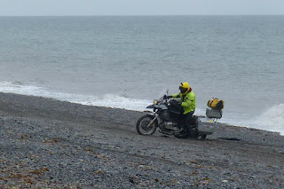
Off we go to the little road and stop at the top of a small hill.  The road goes on down to the beach and looks like lots of vehicles have been in and out.  I decide I can make it down with no problem and we won't have to walk as far.  There is a lesson here, pay attention.

I proceed down the hill like a champ, standing on the pegs like I really know what I'm doing.  Yes sir, looked good too !  But, the beach is not sand, more of a silt and pea gravel mix. Seems a little, uh, boggy.  Oh well, we'll walk the rest of the way to take eagle pictures. Lots and lots of eagle pictures.  Kathy is ecstatic with our being able to get so close to the majestic birds, even if it is starting to rain harder again.


After our fill of taking pictures of eagles we walk back to the bike, Kathy elects to walk back up the hill the same way she came down it.  I start to turn the bike around and the back tire sinks to the axle.  Hmm.  So I lay the bike over and fill in the rut, now I have to pick the bike back up, which is no easy task with the load that is on it.  Finally I get it up and start moving again, I make it a few feet and it sinks again. Repeat.  A few more feet, repeat.  I am exhausted,  I try walking, pushing alongside the bike while I give it throttle. I smell clutch, I feel rain, and I'm sweating.  Note to self, more cardio.  I reach the foot of the hill, I'm spent.  Then I hear an ATV.


Kathy has asked a guy on a four wheeler if he could go down and assist me.  He does and helps me give the bike one final push up the hill to where there is solid ground, not sinking sand. (hum church hymn now)...

I think him profusely,  pick up Kat and away we go, steam escaping from my jacket. Whew !

Back through Anchorage, and on we travel.  We take the Old Palmer hwy by mistake and enjoy the ride immensely.  A small two lane twisty highway that follows the Knik River.  Finally we make Palmer, find a descent motel and crash for the night.  It's been quite a day,  but one I wouldn't trade for anything.  Tomorrow, Valdez.

Pics for Day 21 Homer to Palmer